News
Integrating Earth observation data
21 November 2012
The world looks different through each individual’s eyes – and the same goes for satellites. An ESA team is working on merging these different ‘perspectives’ to produce more accurate satellite data products on our changing lands.
Data from Earth-observing satellites contribute to land surface monitoring – among many other applications – providing consistent global information with historical archives going back over 30 years to document changes.
In order to model land surface changes, predict future changes and study their interaction with the atmosphere, scientists need to quantify surface properties such as vegetation and soil percentage cover, leaf cover and the concentration of photosynthetic active pigments within the canopy.
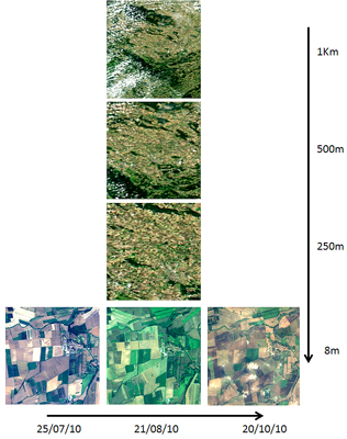
In the image above, are six perspectives from the EO-LDAS test site in Gebesee, Germany. From top to bottom, MODIS images at 1 km, 500 km and 250 m resolution acquired on 21 August 2010. From left to right, Formosat-2 images at 8 m resolution acquired on 27 July 2010, 21 August 2010 and 20 October 2010. Note that, in the time series, a number of factors influence the radiances detected by the instrument. On top of physical evolution of the land surface (i.e. crop growth), differences in the Sun angle and atmospheric conditions affect the light received by the sensor. The EO-LDAS system takes into account all these factors in deriving a physically consistent integration of the data.
Scientists now have access to a large number of land data products thanks to the increasing number of Earth observation missions in orbit. However, there are many challenges in combining data of different resolutions and taken at different times, and under different conditions. The Earth Observation – Land Data Assimilation Scheme (EO-LDAS) aims to overcome these difficulties by developing a system to assimilate satellite observations directly instead of derived products from them.
Under ESA’s Support to Science Element (STSE) initiative, the project team simulates a virtual sensor from observations made by many different sensors and by using assimilation techniques to harmonise the data. This makes the datasets comparable, despite coming from different instruments.
The system will also be used in the cross-calibration of sensors.
Validation of the prototype was recently undertaken to ensure the correct operation of the software and to demonstrate the utility of the approach.
A number of future enhancements have been proposed as the next steps towards a more operational implementation, including improvements to its computational efficiency to allow more extensive real-world validation to be undertaken.
To promote the concept of data assimilation within the land community, an extensive tutorial including software developed under EO-LDAS is available at the EO-LDAS website.